GeoSetter
3.4.16
Size: 18.77 MB
Downloads: 4963
Platform: Windows 8/7/Vista/XP

If you have a large photo album, it may be difficult to remember where you took each picture. Fortunately, a graphical file contains more information, besides the image itself, including geotags. If you want to specify where you took certain pictures and save the information, you can use GeoSetter. It gives you the possibility of reading and editing geographical data in your image files. You can also edit other EXIF, IPTC or XMP data, import pictures from a wide variety of digital cameras, synchronize geotags with GPS data files and more.
The software is designed to work on Windows XP and any later edition. It is absolutely free and it takes about a minute to install its components on your computer. Besides GeoSetter's files, you can also install a shell extension, if you want to import images and start certain procedures from Windows Explorer.
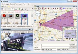
The interface consists of three panels. You can explore your local folders and preview images on the left side and you can assign and edit geotags on the right side, on a Google powered map. The map and image preview panels can be undocked from the main interface and used as separate windows. Each panel comes with its own toolbar, which contains various functions for filtering images, fitting them in the preview area, assigning geotags and more.
GeoSetter makes it quite easy to assign geotags to your pictures. While an image is selected, you can place a position marker on the map and select an option, on the map's toolbar, to assign the marker's coordinates to the selected image. You can perform the same action for each picture and save their changes. When you select a tagged image, its corresponding marker will be highlighted.
Besides assigning position markers, you can also specify the angle from which you took your pictures. While a picture and its marker are selected, you just need to click an option and place a dot, next to the marker, to define the angle and distance. You can add additional information to a picture on a tabbed window. If you assign a position marker before you edit a picture's info, you can fill in certain input fields, like country, city, altitude and others, with a single click. When you select a picture's marker, the software will display a series of details, like date, sub-location and the used camera settings, in a text bubble.
Pros
You can assign geotags to your pictures, just by placing position markers on a map. The software allows you to insert a wide range of information for individual images and you can fill in certain input fields with a single click. Although it comes with many options, using GeoSetter is not difficult and it does not take long to edit a picture's information.
Cons
You may need some time to study all the functions. GeoSetter places everything you need at your disposal to specify where you took your pictures and how.
GeoSetter
3.4.16
Download
GeoSetter Awards

GeoSetter Editor’s Review Rating
GeoSetter has been reviewed by Frederick Barton on 15 Mar 2013. Based on the user interface, features and complexity, Findmysoft has rated GeoSetter 5 out of 5 stars, naming it Essential